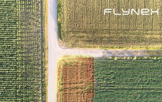
FlyNex at the Agit 2019 in Austria – our review

The spatial view - that was this year's topic of the AGIT expo. The focus was on the spatial perspective of geoinformatics. As the rollout of 5G networks evolves, the transition from storing data to process it in real-time becomes more and more a necessity. In this article, we want to tell you about the experiences we had at the AGIT expo this year.

2020-06-10T15:46:47+02:0030. July 2019|News|

4 reasons to use drones in agriculture

Some farmers already use drones in their daily work. Drones can fly over fields in a short period of time and the data they obtain will help them e.g. determine where to irrigate. Drones can also help protect nature and save lives.

2020-06-10T15:45:36+02:0018. June 2019|News|

15 Tips for Better Web Maps – Part 3

Haven't read it yet? Here's part I and part II Geodata is data with a spatial reference. Depending on estimates, this includes 80-95 % of all data worldwide and thus affects all industries. Maps are the classic way of presenting geodata. In times of [ ... ]

2020-06-10T15:42:32+02:008. January 2019|News|

15 Tips for Better Web Maps – Part 2

Haven´t read the first part? Read it here Maps and map-like representations are wonderfully suitable for the presentation of everything that has a spatial reference. Things have a spatial reference if a concrete location or a geographical area can be assigned [ ... ]

2020-06-10T15:41:40+02:009. October 2018|News|
Go to Top