Warum Unternehmen endlich auf moderne Lösungen setzen sollten
In vielen Immobilienunternehmen und Wohnungsbaugesellschaften trifft man heutzutage noch auf ein weit verbreitetes Problem: Veraltete Bestandsdaten über Grün- und Grauflächen, lückenhafte Aufzeichnungen über Grundstücksgrenzen und fehlende digitale Verwaltungssysteme für das Flächenmanagement.
Doch die rasante Entwicklung von Technologien ermöglicht es uns heute Lösungen zu nutzen, von denen vor einem Jahrzehnt nur zu träumen war. Daher ist es an der Zeit, Probleme wie lückenhafte Bestandsdaten endlich anzugehen und Prozesse effizient, transparent und zukunftsorientiert zu gestalten.
Wie Unternehmen aus den Bereichen Immobilien und Facility-Management von Drohnentechnologie und digitalen Bestandsdaten profitieren können, erfahren Sie im folgenden Artikel.
Die Herausforderung
Im Laufe der Zeit haben sich viele Quartiere verändert. Über die Jahre hinweg wurden Flächen ge- und verkauft oder haben eine andere Verwendung gefunden. Oft wurden diese Veränderungen nicht immer korrekt oder digital festgehalten.
Das Ergebnis: Ungenauigkeiten und mangelnde Transparenz. Wenn beispielsweise Details zu Flächen wie Rasen, Gehölzen oder Sickerflächen benötigt werden, stützen sich Unternehmen oft auf unvollständige Excellisten oder veraltete Papierdokumente. Das ist unglaublich zeitaufwändig und birgt das Risiko von Fehlern und Ungenauigkeiten – falls die Daten am Ende überhaupt existieren. Der letzte Ausweg führt dann meist zu kostspieligen Vermessungsaufträgen.
Welche Auswirkungen fehlende und veraltete Daten haben, zeigt folgendes Praxisbeispiel: Ein Garten- und Landschaftsbauer wurde beauftragt, eine Rasenfläche zu bewirtschaften. Abgerechnet wird pro gemähten Quadratmeter. Der Auftraggeber, ein Immobilienunternehmen, beruft sich auf jahrealte Daten, die eine Fläche von ca. 2.000 m² ergeben. Tatsächlich beträgt die zu bewirtschaftende Rasenfläche aber eigentlich nur 1.500 m². Bei einem angenommenen Preis von 0,70 €/m² ergeben sich pro Mahd unnötige Kosten von 350 €. Bei 10 Einsätzen pro Jahr sind das bereits über 3.000 € an nicht notwendigen Ausgaben. Hochgerechnet auf ein gesamtes Quartier gehen solche Kosten in die hohen fünfstelligen Beträge.
Die Lösung: Digitale Quartiersvermessung mit Drohnen
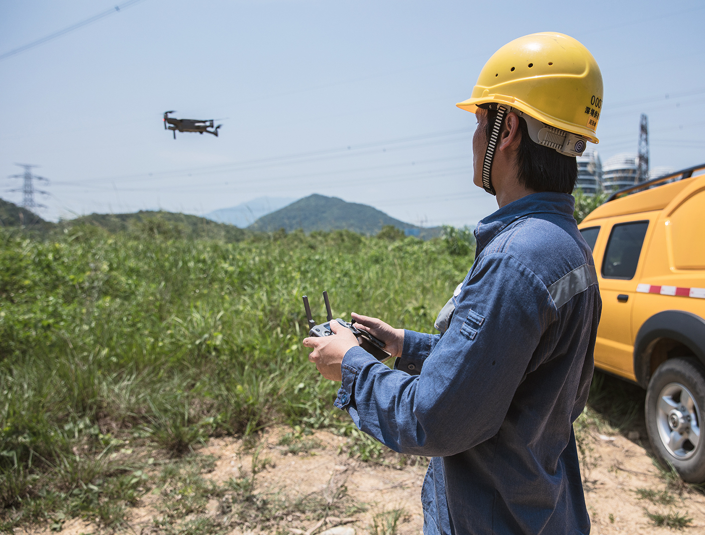
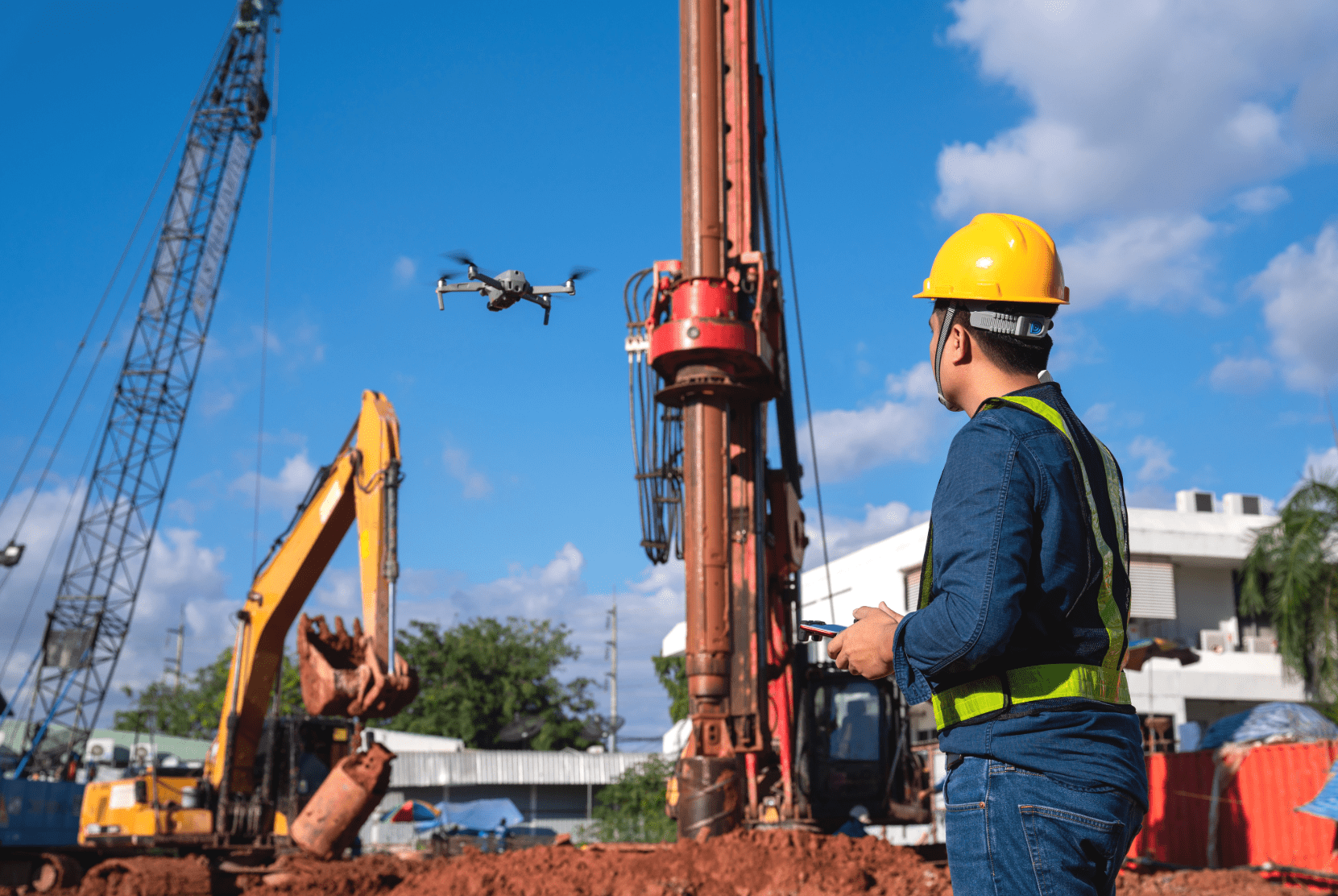
Die Lösung liegt in der Nutzung moderner Technologie, wie der georeferenzierten Datenerhebung mit Drohnen.
Drohnen bieten eine beispiellose Möglichkeit, große Flächen schnell und präzise zu kartieren. In Kombination mit fortschrittlichen Softwareplattformen wie der FlyNex Plattform können diese Daten in 2D und 3D einfach verarbeitet werden, um alle Details von Heckenhöhen bis Sickerflächen abzubilden.
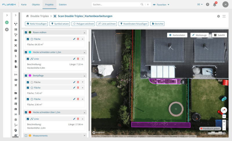
Das Ergebnis: Digitales Datenmanagement
Optimiertes Flächenmanagement: Mit den präzisen Daten aus der digitalen Vermessung können Unternehmen ihre Grün- und Grauflächen effektiver planen und verwalten, sei es für Garten- und Landschaftsarbeiten, Winterdienste oder Gehwegreinigungen. Dienstleister können gezielter eingesetzt werden und deren Angebote besser geprüft werden. In allem führt dies zu geringeren Kosten.
Hohe Auskunftsfähigkeit: Durch den Zugang zu digitalisierten Informationen der Bestände ist es Unternehmen jederzeit möglich, präzise Auskünfte gegenüber Mietern, Dienstleistern oder städtischen Behörden zu geben.
Strategische Planung: Ein klarer Überblick über die Bestände ermöglicht Unternehmen, fundiertere und schnellere Entscheidungen in Bezug auf Neu- und Umbauten zu treffen und die Planung digital durchzuführen.
Besseres Nachhaltigkeitsmanagement: Die genauen Informationen über Grünflächen machen es Unternehmen einfacher, ihre Nachhaltigkeitsziele besser zu definieren und zu kommunizieren. Sie können genaue Aussagen darüber treffen, wie viel Grünfläche sie besitzen und wie diese Flächen genutzt werden, um die Umwelt zu unterstützen.
Rechtliche Absicherung: Transparente und präzise Daten bedeuten, dass bei Nachfragen oder Anfechtungen durch Mieter klare und rechtssichere Antworten gegeben werden können. Das fördert Vertrauen und minimiert potenzielle Konflikte. Auch in anderen Fällen bieten die Daten eine solide rechtliche Grundlage, die besonders bei Streitigkeiten oder rechtlichen Fragestellungen von Nutzen ist.
Die Vorteile sind nahezu endlos. Zusammenfassend lässt sich sagen, dass Unternehmen durch die Vermessung mit Drohnen und der digitalen Verwaltung der Daten hohe Summen an unnötigen Kosten einsparen, endlich einen transparenten Informationsfluss haben und schneller auskunftsfähig sind.
Fazit und Ausblick
Die Drohnenvermessung revolutioniert nicht nur das Bestandsdatenmanagement, sondern setzt auch neue Maßstäbe. Das Potenzial dieser Technologie für die Immobilienbranche ist enorm und bietet Unternehmen die Möglichkeit, ihre Arbeit effizienter, genauer und nachhaltiger zu gestalten.
Beispielsweise fördert diese Technologie auch eine zukunftsfähige Quartiersentwicklung. Mit genauen und aktuellen Daten lässt sich aus jeder Fläche das volle Potenzial ausschöpfen und der Nutzen maximieren, sei es für Neubauten, Renaturierung oder die Erweiterung bestehender Strukturen. Projekte wie Spielplätze, Bepflanzungen oder andere Grünanlagen können effizient und umweltfreundlich geplant und umgesetzt werden.
Die Digitalisierung der Quartiersvermessung durch Drohnentechnologie ist ein Game-Changer für Immobilien- und Facility-Management-Unternehmen. Sie bietet eine Chance, sich von veralteten Systemen und ungenauen Daten zu verabschieden. Mit digitaler Quartiersvermessung können Immobilienunternehmen ihre Bestände endlich effektiv verwalten, Kosten optimieren und transparent agieren.
Kontaktieren Sie uns gerne, wenn Sie Interesse an unseren individuellen Lösungen und Services haben.